
Handheld GPS navigation devices are some of the most reliable tools I can carry when exploring unfamiliar terrain, traveling through remote locations, or enjoying outdoor adventures where cellular service may be limited or unavailable.
They provide accurate positioning, dependable route tracking, waypoint management, and long battery life, helping me navigate with confidence whether I am hiking, boating, hunting, cycling, camping, or working in the field.
Many models also include advanced features such as topographic maps, satellite support, electronic compasses, altimeters, and emergency communication capabilities, making them valuable companions for both recreational users and professionals.
In this guide, I’ll cover the key features that matter most, review some of the top handheld GPS navigation devices available today, explain what to look for in a buying guide, and answer frequently asked questions to help you choose the right device for your navigation needs.
Best Handheld GPS Navigation Devices
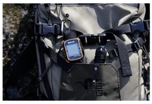
1) Garmin GPSMAP 79sc, Marine GPS
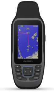
The Garmin GPSMAP 79sc is an excellent choice for boaters, anglers, sailors, and outdoor enthusiasts who need a dependable handheld GPS navigation device built for marine environments. Its rugged construction, floating design, and water-resistant housing make it particularly useful on the water, where durability and reliability are essential.
The unit features a high-resolution, sunlight-readable 6-inch color display protected by scratch-resistant, fogproof glass, allowing clear visibility even in bright outdoor conditions.
One of the biggest advantages of the GPSMAP 79sc is its extensive satellite support. It connects to GPS, GLONASS, BeiDou, Galileo, QZSS, and SBAS satellite systems, providing accurate positioning and reliable tracking almost anywhere in the world.
This broad satellite compatibility helps maintain strong signal reception in challenging environments, whether navigating coastal waters, remote shorelines, or inland waterways.
The GPSMAP 79sc comes preloaded with BlueChart g3 coastal charts, giving users detailed navigation information for North American coastal regions.
These charts display water depths, navigation aids, shorelines, and other important marine details that help improve situational awareness on the water. Additional regional charts can also be added through compatible chart purchases, expanding its usefulness for international travel and boating adventures.
Storage capacity is another strong point. With 8 GB of internal memory, the device can save up to 10,000 waypoints, 250 routes, and 300 fitness activity files. This generous capacity allows users to store years of favorite fishing locations, navigation routes, and travel records without constantly managing memory.
For navigation precision, Garmin includes a built-in 3-axis tilt-compensated electronic compass that provides accurate heading information even when the unit is stationary.
The integrated barometric altimeter further enhances navigation by tracking pressure changes and delivering more precise altitude readings. These features are especially valuable for users who venture beyond marine environments and into hiking or backcountry exploration.
Battery performance is well suited for extended outings. The GPSMAP 79sc operates on two user-replaceable AA batteries and delivers up to 20 hours of battery life in GPS mode. Users can also power the device through an optional 12V Garmin accessory connection, providing additional flexibility during longer trips.
Connectivity is straightforward with USB support, and the device is compatible with smartphones and tablets for expanded functionality. The package includes the GPSMAP 79sc unit, lanyard, USB cable, and documentation, making it ready for immediate use right out of the box.
Pros
- Rugged construction designed for marine environments
- Floats if accidentally dropped in water
- High-resolution sunlight-readable color display
- Scratch-resistant and fogproof glass
- Supports GPS, GLONASS, BeiDou, Galileo, QZSS, and SBAS
- Preloaded BlueChart g3 coastal charts
- Stores up to 10,000 waypoints and 250 routes
- Built-in electronic compass works while stationary
- Integrated barometric altimeter
- Up to 20 hours of battery life
- User-replaceable AA batteries
- Compatible with smartphones and tablets
Cons
- No built-in SD card slot for memory expansion
The Garmin GPSMAP 79sc is one of the best handheld GPS navigation devices for marine use thanks to its floating design, advanced navigation capabilities, extensive waypoint storage, and reliable multi-satellite tracking.
Its combination of rugged durability, marine charting, and long battery life makes it a dependable companion for serious boaters and outdoor adventurers.
2) Swami KISS 2.0 Handheld Golf GPS
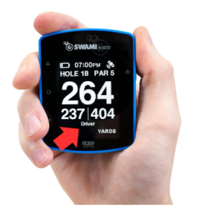
The Swami KISS 2.0 Handheld Golf GPS is a practical and easy-to-use device that helps golfers make more informed decisions on the course. Designed with simplicity and convenience in mind, this handheld GPS provides accurate yardage information and useful game-management features without overwhelming users with complicated settings.
Its compact design and extensive course coverage make it a strong choice for golfers seeking a reliable handheld GPS navigation device.
One of the most appealing features of the Swami KISS 2.0 is its access to more than 38,000 preloaded course maps. The device automatically recognizes the course being played, allowing golfers to start using it quickly without manual setup.
Accurate distance measurements help players choose the right club with greater confidence, while individual shot distance tracking allows users to monitor how far each shot travels for improved course strategy.
The built-in i-Caddie technology adds another level of assistance during a round. Based on the golfer’s distance from the target, the system provides personalized club recommendations that can help simplify club selection.
This feature is particularly useful for recreational golfers looking to improve consistency and make smarter decisions throughout the round.
The Swami KISS 2.0 offers two display modes for flexibility and ease of use. Golfers can view front, center, and back yardages to the green on one screen or choose a simplified display that prioritizes the center distance while providing front and back measurements on a secondary screen. This straightforward presentation helps eliminate guesswork and allows players to focus on their shots.
In addition to distance information, the device functions as a scorekeeping companion. Golfers can track their scorecard, greens in regulation (GIR), and putts per round (PPR) directly on the unit. These statistics provide valuable insight into performance trends and can help identify areas for improvement over time.
Convenience is further enhanced by the integrated magnetic mount. The powerful magnet allows the GPS unit to attach securely to most golf cart frames, keeping it easily accessible throughout the round. The water and fog resistant construction also helps ensure dependable performance during changing weather conditions, while the universal micro USB charging port makes recharging simple and convenient.
The Swami KISS 2.0 combines accurate yardage information, extensive course coverage, useful performance tracking tools, and golfer-friendly features into an affordable package. Its straightforward operation makes it especially appealing to players who want dependable GPS guidance without unnecessary complexity.
Pros
- More than 38,000 preloaded golf course maps
- Automatic course recognition for quick setup
- Accurate distance measurements to improve club selection
- Individual shot distance tracking
- i-Caddie technology provides club recommendations
- Two easy-to-read distance display modes
- Tracks scorecard, GIR, and PPR statistics
- Integrated magnetic mount for convenient cart attachment
- Water and fog resistant construction
- Simple micro USB charging
- User-friendly interface suitable for golfers of all skill levels
Cons
- Lacks advanced touchscreen functionality
The Swami KISS 2.0 is one of the best handheld GPS navigation devices for golfers who want accurate yardages, extensive course coverage, and useful performance tracking in a simple and affordable package.
Its combination of reliable GPS guidance, i-Caddie assistance, and convenient magnetic mounting makes it a valuable companion for players looking to improve their game.
3) Garmin inReach Mini 2
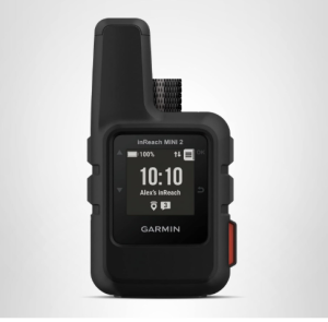
The Garmin inReach Mini 2 is an exceptional handheld GPS navigation device designed for adventurers who travel beyond cellular coverage.
Combining GPS navigation, satellite communication, and emergency response capabilities in an incredibly compact package, this device is ideal for hikers, backpackers, hunters, climbers, and remote travelers who need reliable connectivity and navigation wherever they go.
Weighing only 99 grams and measuring just under four inches in length, the inReach Mini 2 is one of the lightest satellite communicators available. Its rugged polymer construction and IPX7 water rating help it withstand challenging outdoor environments, while the sunlight-readable monochrome display remains visible in bright conditions. The compact size allows it to fit easily into a pocket, backpack strap, or gear pouch without adding noticeable bulk.
Navigation performance is impressive thanks to its high-sensitivity GPS receiver and TracBack routing feature. TracBack helps users retrace their path and navigate back to their starting point using the same route they originally traveled.
This can be particularly useful in unfamiliar terrain or during low-visibility conditions. The built-in digital compass also provides accurate heading information even when standing still, making route finding more convenient during outdoor adventures.
What separates the inReach Mini 2 from many traditional GPS devices is its global satellite communication capability through the Iridium satellite network. With an active satellite subscription, users can send and receive two-way text messages from virtually anywhere in the world, even when no mobile signal is available.
The device also includes an interactive SOS function that can connect users with emergency response services when assistance is needed. These communication features provide significant peace of mind for solo travelers and backcountry explorers.
Location sharing is another valuable capability. Users can send their coordinates through messages or share their progress with family and friends using the MapShare feature. This allows loved ones to follow a trip remotely and stay informed about a traveler’s location. For extended expeditions, this feature can be particularly reassuring.
The Garmin Explore ecosystem further expands the device’s functionality. By pairing the inReach Mini 2 with a compatible smartphone through Bluetooth, users gain access to topographical maps, trip planning tools, waypoint creation, route management, and activity organization through the Garmin Explore app and website.
While the device itself does not include onboard maps, the smartphone integration provides a more detailed mapping experience when needed.
Battery performance is another strong advantage. The rechargeable lithium-ion battery delivers up to 14 days of operation in 10-minute tracking mode, allowing users to embark on multi-day adventures without frequent charging.
USB charging adds convenience, and the device can also pair with compatible Garmin wearables and handheld GPS units for expanded communication and emergency capabilities.
Customer feedback consistently highlights the inReach Mini 2’s reliability in remote regions across North America, Central America, and other international destinations. Its portability and dependable satellite coverage make it a trusted companion for outdoor enthusiasts who regularly venture beyond traditional communication networks.
Pros
- Extremely compact and lightweight design
- Global two-way satellite messaging capability
- Interactive SOS emergency communication feature
- Reliable coverage through the Iridium satellite network
- TracBack routing helps navigate back to starting locations
- Digital compass provides heading information while stationary
- Location sharing through MapShare and message coordinates
- Bluetooth connectivity with smartphones and Garmin devices
- Garmin Explore app supports trip planning and topographical mapping
- Up to 14 days of battery life in tracking mode
- Durable IPX7 water-resistant construction
- Excellent choice for remote travel and backcountry adventures
Cons
- Active satellite subscription required for messaging and SOS features
The Garmin inReach Mini 2 is one of the best handheld GPS navigation devices for outdoor enthusiasts who prioritize safety, communication, and portability.
Its combination of satellite messaging, emergency SOS functionality, reliable GPS navigation, and long battery life makes it an invaluable tool for exploring remote areas where traditional communication methods are unavailable.
4) Dogtra PATHFINDER2 MINI Compass Live GPS
The Dogtra PATHFINDER2 MINI Compass Live GPS is a versatile handheld GPS navigation device designed for dog owners, hunters, trainers, and outdoor enthusiasts who need reliable tracking and training capabilities in the field.
Combining real-time GPS tracking, a dedicated handheld controller, and advanced dog training functions, this system delivers a comprehensive solution for managing dogs over long distances without relying on cellular service.
One of the most impressive aspects of the PATHFINDER2 MINI Compass is its dedicated handheld unit with a bright 2-inch LCD screen and built-in compass. Unlike systems that depend entirely on a smartphone, this handheld controller operates independently, allowing users to monitor and manage their dogs without draining their phone battery.
The screen displays valuable information including distance, direction, speed, and movement status, helping handlers maintain awareness of their dogs’ locations at all times.
Tracking performance is excellent thanks to rapid GPS updates every two seconds. These frequent updates provide near real-time positioning, making it easier to locate dogs quickly even when they are moving through dense cover or challenging terrain.
The integrated compass further improves navigation by helping users determine the exact direction of their dogs during hunts, training sessions, or outdoor adventures.
Training functionality is equally impressive. The system offers five training modes including Nick, Constant, Tone, Pager, and LED Locate Light. Users can customize button assignments to match their preferred training style or dedicate controls to specific dogs.
This flexibility makes the system suitable for both professional trainers and recreational handlers who want responsive control while maintaining consistency during training sessions.
Built for demanding outdoor use, the PATHFINDER2 MINI Compass features a four-mile range and rugged IPX9K waterproof construction. Whether working in heavy rain, muddy conditions, or rough terrain, the system is designed to withstand challenging environments.
The collar is intended for dogs weighing 15 pounds or more, making it suitable for many hunting and sporting breeds.
The included app expands the system’s capabilities even further. Users gain access to detailed satellite imagery, offline maps, public land boundaries, and customizable GPS fencing without paying subscription fees.
Since the system does not require cellular coverage for tracking, it remains highly useful in remote locations where traditional mobile networks are unavailable.
Scalability is another advantage. The PATHFINDER2 receiver system can track up to 21 dogs, with four dogs displayed simultaneously on the handheld screen and instant switching available between tracked animals. Fast USB-C charging, silent vibration notifications, and a handheld locate function add convenience during long days in the field.
Dogtra’s long-standing reputation for quality is reflected in the design and durability of the PATHFINDER2 MINI Compass. With over four decades of experience producing training equipment, the company has created a system that balances dependable GPS tracking with practical training tools for serious dog handlers.
Pros
- Dedicated handheld controller operates independently of a smartphone
- Bright 2-inch LCD screen with built-in compass
- Fast two-second GPS location updates
- Real-time tracking information including speed, direction, and distance
- Four-mile operating range
- Five customizable training modes
- User-programmable button assignments
- No subscription fees required
- Offline maps and satellite imagery available through the app
- GPS fencing capabilities
- Tracks up to 21 dogs
- Displays four dogs simultaneously
- IPX9K waterproof construction
- USB-C charging support
- Silent vibration alerts available
Cons
- Primarily designed for dog tracking and training rather than general navigation
The Dogtra PATHFINDER2 MINI Compass Live GPS is one of the best handheld GPS navigation devices for dog tracking and training.
Its combination of real-time GPS updates, independent handheld operation, advanced training controls, offline mapping, and rugged durability makes it an outstanding choice for hunters, trainers, and active dog owners who demand reliable performance in the field.
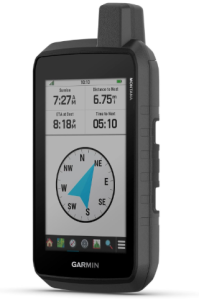
5) Garmin GPSMAP H1i Plus, Premium GPS Handheld Navigator
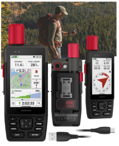
The Garmin GPSMAP H1i Plus is a premium handheld GPS navigation device built for adventurers who demand reliable navigation, advanced communication capabilities, and exceptional durability in remote environments.
Combining powerful GPS technology with satellite communication tools, cameras, voice controls, and extensive mapping options, this navigator is designed for serious hikers, explorers, hunters, overlanders, and outdoor professionals.
One of the most impressive aspects of the GPSMAP H1i Plus is its integrated inReach Plus technology. With an active satellite subscription, users can stay connected even when far beyond cellular coverage.
The device supports two way satellite messaging, allowing users to exchange text messages, send photos, and share voice messages directly through the built-in camera and microphone. This communication capability provides valuable peace of mind during extended adventures in remote regions.
Safety is another major strength of this navigator. The integrated SOS feature allows users to contact the 24/7 Garmin Response international emergency coordination center when assistance is needed. For solo travelers and backcountry explorers, having access to emergency communication can be invaluable in critical situations.
The GPSMAP H1i Plus features a bright 3.5 inch sunlight-readable touchscreen that remains responsive while wearing gloves. The chemically strengthened glass helps protect the display from scratches, while physical buttons provide additional control when weather conditions or gloves make touchscreen operation less convenient. This hybrid control design delivers flexibility across a wide range of outdoor situations.
Navigation performance is excellent thanks to multi band GPS and multi GNSS support. By accessing multiple satellite systems and frequency bands, the device delivers highly accurate positioning and dependable route tracking in challenging terrain.
Preloaded TopoActive maps help users navigate trails immediately, while downloadable high resolution satellite imagery provides a detailed view of the surrounding landscape. Users can also subscribe to Outdoor Maps+ for additional premium mapping content.
Durability is another area where the GPSMAP H1i Plus excels. The unit is engineered to meet MIL STD 810 standards for thermal resistance, shock protection, vibration resistance, and water resistance with an IP67 rating.
Whether facing rain, extreme temperatures, rugged trails, or rough handling, the device is built to continue performing in demanding outdoor conditions.
The integrated front and rear cameras add a unique level of functionality. Users can capture photos of their journey, document routes, and even take selfies during adventures. Combined with satellite sharing capabilities, these cameras help travelers communicate experiences from virtually anywhere.
A built-in flashlight increases the device’s versatility. It can be used as a practical torch during nighttime travel or as a beacon to help signal for assistance during emergencies. Voice command functionality further improves usability by allowing users to perform tasks such as taking photos, starting tracking sessions, and sending check-ins without manually navigating menus.
Battery life is exceptional. The GPSMAP H1i Plus can operate for up to 145 hours in all satellite systems plus multi band mode when using SatIQ technology. Expedition mode extends battery life to an impressive 845 hours, making it suitable for extended trips where charging opportunities are limited. The included Wearable4U PowerBank adds even more flexibility for long adventures.
Pros
- Integrated inReach Plus satellite communication capabilities
- Two way satellite messaging with text, photo, and voice sharing
- Interactive SOS emergency response feature
- Bright sunlight-readable 3.5 inch touchscreen
- Glove-friendly display operation
- Physical buttons provide additional control options
- Multi band GPS and multi GNSS support for excellent accuracy
- Preloaded TopoActive maps
- Downloadable high resolution satellite imagery
- Compatible with Outdoor Maps+ premium content
- Front and rear integrated cameras
- Built-in flashlight for navigation and emergency signaling
- Voice command functionality
- MIL STD 810 durability certification
- IP67 water resistance
- Exceptional battery life
- Includes power bank and essential accessories
Cons
- Satellite communication features require an active subscription
The Garmin GPSMAP H1i Plus is one of the best handheld GPS navigation devices available for outdoor enthusiasts who need advanced navigation, dependable satellite communication, and rugged durability.
Its combination of accurate positioning, emergency communication tools, extensive mapping options, integrated cameras, and remarkable battery life makes it an outstanding companion for adventures far beyond the reach of cellular networks.
6) Garmin Montana® 710, Rugged GPS Handheld Navigator
The Garmin Montana® 710 is a powerful handheld GPS navigation device designed for outdoor enthusiasts who need a large display, dependable navigation tools, and rugged durability.
Whether you enjoy hiking, overlanding, hunting, boating, off road exploration, or backcountry travel, this navigator delivers a versatile combination of mapping, navigation, and outdoor tracking features that make it one of the best handheld GPS navigation devices available.
One of the first things users will notice is the large 5 inch glove-friendly touchscreen. The bright color display is easy to read in outdoor conditions and provides plenty of space for viewing maps, routes, and navigation data.
The touchscreen remains practical when wearing gloves, making it useful for outdoor activities in cold weather or rugged environments. The Montana 710 also supports a variety of mounting options, allowing users to adapt the device for hiking, vehicle navigation, boating, or other adventures.
Navigation capabilities are impressive thanks to the included TopoActive maps. These detailed maps help users explore trails, roads, and outdoor destinations right out of the box. Additional mapping options further increase flexibility, including City Navigator maps for street navigation and BlueChart g3 charts for marine environments.
Users can also download high resolution satellite imagery, providing realistic overhead views that help identify landmarks, terrain features, and potential routes with greater confidence.
Storage capacity is another area where the Montana 710 excels. The device includes 32 GB of internal memory, providing ample room for additional maps, routes, waypoints, and navigation data. Users who subscribe to Outdoor Maps+ can access an extensive library of premium mapping content and download it directly to the device through Wi Fi connectivity, expanding its usefulness for a wide variety of outdoor pursuits.
Built for demanding conditions, the Montana 710 meets MIL STD 810 standards for thermal resistance, shock resistance, and vibration resistance. It also carries an IPX7 water resistance rating, allowing it to withstand rain, splashes, and other challenging weather conditions.
This durable construction gives users confidence when navigating remote environments where equipment reliability is essential.
The built-in ABC sensor package enhances navigation accuracy and environmental awareness. The altimeter provides elevation data, the barometer helps monitor changing weather conditions, and the 3 axis electronic compass delivers accurate directional information even when standing still. Together, these sensors provide valuable information for hikers, climbers, and outdoor explorers.
Battery flexibility is another major advantage. The rechargeable lithium-ion battery delivers up to 24 hours of use in GPS mode and an impressive 432 hours in expedition mode. For longer trips, the device can also operate using traditional AA batteries, offering an additional backup power option when recharging is not available. USB-C charging further simplifies power management during travel.
The Montana 710 integrates with the Garmin Explore smartphone app, allowing users to plan routes, manage waypoints, review trip data, and organize outdoor activities from a compatible mobile device. Active weather forecasts can also be accessed through the Garmin Connect app, helping users stay informed about changing conditions before and during their adventures.
Pros
- Large 5 inch glove-friendly touchscreen
- Bright color display that is easy to view outdoors
- Includes detailed TopoActive maps
- Supports additional street and marine mapping options
- Downloadable high resolution satellite imagery
- Generous 32 GB internal storage capacity
- Compatible with Outdoor Maps+ premium content
- Durable MIL STD 810 construction
- IPX7 water resistance
- Built-in altimeter, barometer, and electronic compass
- Up to 24 hours of battery life in GPS mode
- Up to 432 hours in expedition mode
- Can operate using rechargeable battery or AA batteries
- USB-C charging support
- Garmin Explore app compatibility
- Access to active weather forecasts through smartphone integration
Cons
- Additional maps and premium mapping services may require extra purchases
The Garmin Montana® 710 is one of the best handheld GPS navigation devices for adventurers who want a large display, detailed mapping capabilities, rugged durability, and flexible power options. Its combination of advanced navigation tools, extensive storage, outdoor sensors, and dependable construction makes it an excellent companion for exploring both remote wilderness areas and established trails.
7) Bryton Rider S810 3.5 Inch Color Touchscreen GPS
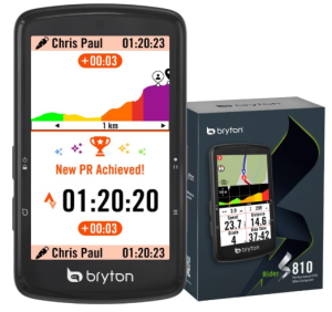
The Bryton Rider S810 is a feature-rich GPS navigation device built for cyclists who demand reliable navigation, detailed ride data, and exceptional battery life.
Designed for road cycling, gravel riding, bikepacking, and long-distance adventures, this GPS unit combines a large color touchscreen, offline navigation, advanced training tools, and extensive sensor compatibility in a package that performs well both on and off the beaten path.
One of the most appealing aspects of the Rider S810 is its large 3.5 inch color touchscreen. The display provides excellent visibility for maps, ride metrics, and navigation prompts while riding. An adaptive light sensor automatically adjusts screen brightness based on surrounding conditions, helping maintain readability whether cycling under bright sunlight or through shaded forest trails.
Physical anti-slip buttons complement the touchscreen, providing dependable control when riding through rough terrain, wearing gloves, or encountering wet weather.
Navigation capabilities are particularly strong. The Rider S810 comes equipped with preloaded maps and true offline navigation functionality. Because routing relies on GPS satellite positioning rather than cellular service, cyclists can confidently explore remote roads and backcountry routes without worrying about signal coverage.
Turn by turn navigation keeps riders on course, while automatic route recalculation quickly provides updated guidance whenever a wrong turn is taken.
Battery performance is one of the strongest features of this GPS device. With up to 50 hours of battery life, the Rider S810 is well suited for century rides, multi-day bikepacking adventures, endurance events, and extended gravel excursions.
Real-time battery monitoring helps riders manage power usage efficiently and provides confidence during long days far from charging opportunities.
For performance-focused cyclists, the Rider S810 includes advanced training features such as Strava Live Segments and Climb Challenge 2.0. Strava Live Segments allow riders to compare their current efforts against personal records in real time, creating additional motivation during training sessions.
Climb Challenge 2.0 provides visual information about upcoming gradients, elevation gain, and remaining ascent, helping cyclists pace themselves more effectively during demanding climbs.
The device also serves as a central hub for cycling accessories and performance data. Support for ANT+ sensors allows connectivity with heart rate monitors, cadence sensors, speed sensors, power meters, and rear-view radar systems.
This broad compatibility enables detailed ride analysis and enhanced situational awareness. Indoor cyclists can also connect the Rider S810 to compatible smart trainers through ANT+ FE-C technology, enabling structured workouts and virtual riding experiences.
The Bryton Active App expands the overall experience by simplifying route planning, workout downloads, ride analysis, and data management. Ride information can be uploaded through Bluetooth and automatically synchronized with popular training platforms such as Strava, TrainingPeaks, and Komoot. This integration makes it easy to review performance, share achievements, and plan future adventures.
The combination of advanced navigation tools, long battery life, training support, and extensive connectivity makes the Rider S810 an excellent companion for cyclists seeking a dependable GPS navigation device for both recreational and competitive riding.
Pros
- Large 3.5 inch color touchscreen
- Adaptive light sensor improves visibility in changing conditions
- Physical buttons provide reliable control on rough terrain
- Up to 50 hours of battery life
- Preloaded maps with offline navigation
- Turn by turn route guidance
- Automatic route recalculation
- Works without cellular service
- Strava Live Segments support
- Climb Challenge 2.0 for detailed climbing information
- Compatible with heart rate, cadence, speed, and power sensors
- Supports rear-view radar systems
- Smart trainer compatibility through ANT+ FE-C
- Bluetooth synchronization with training platforms
- Route planning and ride analysis through the Bryton Active App
Cons
- Primarily optimized for cycling rather than general outdoor navigation
The Bryton Rider S810 is one of the best handheld GPS navigation devices for cyclists who want reliable offline navigation, impressive battery life, advanced training tools, and extensive sensor compatibility.
Its combination of accurate route guidance, performance tracking, and long-distance capability makes it an excellent choice for riders tackling everything from daily training sessions to multi-day cycling adventures.
8) Bushnell BackTrack Mini GPS Navigation
The Bushnell BackTrack Mini GPS Navigation device is a compact and practical solution for hikers, backpackers, hunters, and outdoor enthusiasts who want a simple way to find their way back when venturing beyond cellular coverage.
Designed to provide reliable GPS navigation without depending on a smartphone, this lightweight handheld unit focuses on straightforward route tracking and backtracking, making it one of the best handheld GPS navigation devices for users who prefer simplicity over complex mapping systems.
One of the most useful features of the BackTrack Mini is its ability to record trips and waypoints using GPS technology. As you travel, the device creates a breadcrumb trail that displays where you have been. If you need to return to your starting point, campsite, vehicle, or trailhead, the BackTrack function guides you back along your recorded route.
This functionality can be especially valuable in unfamiliar terrain where smartphone batteries may be depleted or cellular service is unavailable.
The device features a 2.25 inch LCD display with a 480 x 272 resolution that provides clear visibility of navigation information. Large glove-friendly buttons make operation simple, even when wearing gloves during cold weather hikes or hunting trips.
The straightforward controls allow users to quickly mark waypoints, review routes, and access navigation functions without navigating through complicated menus.
The BackTrack Mini also provides useful environmental data that can help users stay informed while outdoors. Elevation gain and decline tracking allows hikers to monitor their progress across changing terrain, while the built-in barometric pressure information offers insight into weather conditions.
The device also displays sunrise, sunset, moonrise, and moonset times, which can be particularly useful for hunters, campers, and anyone planning activities around daylight hours.
Bluetooth connectivity expands the device’s capabilities by allowing users to sync trips and waypoints with the Bushnell Connect app on a compatible smartphone. This makes it easier to store navigation data, review previous trips, and share routes with others.
The ability to transfer information between the device and smartphone adds convenience while maintaining the independence of a dedicated GPS navigator.
Portability is another strong advantage. Measuring only 3 inches long and weighing approximately 2 ounces, the BackTrack Mini can easily fit into a pocket, backpack, or gear pouch. The included carabiner clip allows users to attach it securely to their equipment for quick access during outdoor activities.
Battery performance is well suited for extended outings. The rechargeable battery can provide up to 35 hours of operation, reducing the need for frequent charging during multi-day trips. Charging is simple through a standard Micro USB connection, eliminating the need for specialized batteries or chargers.
The rugged waterproof construction helps the BackTrack Mini withstand challenging outdoor conditions, including rain, mud, and rough handling. This durability enhances its reliability during backcountry adventures where dependable navigation equipment is essential.
Pros
- Simple and easy-to-use GPS navigation
- Reliable BackTrack feature guides users back to starting locations
- Breadcrumb trail tracking shows traveled routes
- Waypoint marking and trip recording capabilities
- Compact and lightweight design
- Easy-to-read LCD display
- Large glove-friendly buttons
- Elevation gain and decline tracking
- Barometric pressure monitoring
- Displays sunrise, sunset, moonrise, and moonset times
- Bluetooth connectivity for smartphone syncing
- Compatible with the Bushnell Connect app
- Rechargeable battery with up to 35 hours of operation
- Rugged waterproof construction
- Includes carabiner clip for convenient carrying
Cons
- Limited mapping features compared to advanced GPS units
The Bushnell BackTrack Mini GPS Navigation device is one of the best handheld GPS navigation devices for outdoor enthusiasts who want a simple, lightweight, and dependable way to track routes and return safely to their starting point.
Its combination of breadcrumb navigation, waypoint tracking, environmental data, and long battery life makes it an excellent companion for hiking, backpacking, hunting, and backcountry exploration.
9) Oumefar A6 Handheld Navigation Compass
The Oumefar A6 Handheld Navigation Compass is a practical GPS navigation device designed for outdoor enthusiasts, field workers, surveyors, and professionals who need reliable positioning and route tracking in remote environments.
Combining dual satellite support, coordinate storage, route recording, and measurement tools, this handheld navigator offers a versatile solution for a wide range of outdoor and industrial applications.
One of the most appealing features of the Oumefar A6 is its GPS and BeiDou dual satellite system. This combination improves positioning reliability and provides impressive accuracy of up to 1 meter under suitable conditions.
Whether navigating hiking trails, locating fishing spots, crossing remote terrain, or conducting field surveys, the device delivers dependable location information that can help users stay on course.
The A6 includes support for track navigation and route recording, making it useful for both recreational adventures and professional tasks. Users can save up to 1,000 coordinate points, allowing them to mark campsites, water sources, fishing locations, inspection points, or survey markers.
This generous storage capacity makes it easy to organize and revisit important locations without constantly deleting data.
The 2.4 inch color LCD display provides clear visibility of navigation information, coordinates, and route data. The interface is designed for straightforward operation, making it accessible for users who want a dedicated navigation device without a steep learning curve. A built-in compass further enhances navigation by helping users maintain direction during travel and route planning.
Battery performance is another strong advantage. The integrated 3,500mAh rechargeable lithium battery is designed for extended outdoor use, helping users remain productive during long workdays, expeditions, and multi-hour field operations. USB charging adds convenience by allowing recharging through commonly available power sources.
Durability is an important consideration for any outdoor navigation tool, and the Oumefar A6 is built to handle demanding environments. Its IP65 rating provides protection against dust, rain, and accidental splashes, making it suitable for use in changing weather conditions.
The rugged housing is designed to withstand the challenges commonly encountered during outdoor activities and fieldwork.
In addition to traditional navigation functions, the A6 includes area and length measurement capabilities. These tools increase its usefulness for forestry projects, agricultural land measurement, park planning, geological surveys, communication network planning, and site inspections.
The device’s versatility extends well beyond recreational navigation, making it a valuable tool for professionals who need accurate positioning and measurement functions in the field.
The Oumefar A6 is also well suited for common outdoor activities such as hiking, fishing, camping, orienteering, and road navigation. The ability to record routes and store location data helps users confidently explore unfamiliar areas while maintaining access to important reference points.
Pros
- GPS and BeiDou dual satellite support
- Accurate positioning with up to 1 meter accuracy
- Stores up to 1,000 coordinate points
- Track navigation and route recording capabilities
- Built-in compass for directional guidance
- Large 3,500mAh rechargeable battery
- USB charging support
- 2.4 inch color LCD display
- Area and length measurement functions
- IP65 protection against dust and rain
- Durable construction for outdoor environments
- Suitable for recreational and professional applications
- Useful for hiking, fishing, camping, surveying, and inspections
- Lightweight and portable design
Cons
- Smaller display than premium GPS navigation units
The Oumefar A6 Handheld Navigation Compass is one of the best handheld GPS navigation devices for users seeking an affordable and versatile navigation tool.
Its combination of dual satellite positioning, extensive coordinate storage, route recording, measurement capabilities, and rugged durability makes it a dependable companion for outdoor adventures, fieldwork, and professional surveying applications.
Next read: 8 Best Hunting Sight Magnifers
Factors To Consider When Choosing The Best Handheld GPS Navigation Devices
1. GPS Accuracy and Satellite Support
One of the most important factors to consider is navigation accuracy. A quality handheld GPS device should support multiple satellite systems such as GPS, GLONASS, Galileo, BeiDou, or other global navigation networks.
Devices that can connect to several satellite constellations typically provide more reliable positioning, faster signal acquisition, and improved performance in challenging environments such as dense forests, mountains, canyons, and remote wilderness areas.
2. Mapping and Navigation Features
The quality of mapping features can greatly impact the overall navigation experience. Some devices include topographic maps, coastal charts, street maps, or satellite imagery, while others focus on basic waypoint tracking and route recording.
Consider whether you need turn by turn navigation, offline maps, route planning, waypoint management, breadcrumb trails, or specialized maps for hiking, boating, cycling, or off road travel.
3. Battery Life and Power Options
Battery performance is critical for outdoor adventures, especially when traveling far from charging sources. Devices with longer operating times are better suited for extended trips, multi day hikes, and remote expeditions.
It is also worth considering whether the unit uses rechargeable batteries, replaceable batteries, or both. Flexible power options can provide additional peace of mind during long outings.
4. Display Size and Ease of Use
A clear, readable display makes navigation much easier in outdoor conditions. Larger screens provide more map detail and easier route viewing, while compact displays often improve portability. Features such as sunlight readability, touchscreen controls, glove-friendly operation, and physical buttons can significantly improve usability in different weather conditions and environments.
5. Durability and Weather Resistance
Outdoor navigation devices are often exposed to rain, dust, mud, extreme temperatures, and accidental drops. A rugged design with strong water resistance and shock protection can greatly increase reliability in the field. Look for devices with recognized durability ratings that indicate protection against environmental challenges and rough handling.
6. Storage Capacity and Route Management
Storage capacity determines how many maps, routes, waypoints, and recorded tracks a device can hold. Users who frequently travel to different regions or manage large collections of navigation data should prioritize devices with generous internal storage.
The ability to save thousands of waypoints and extensive route histories can be particularly valuable for explorers, surveyors, hunters, and outdoor professionals.
7. Connectivity and Smart Features
Modern handheld GPS devices often include wireless connectivity options that expand their functionality. Bluetooth, Wi Fi, smartphone integration, and companion apps can simplify route planning, trip analysis, data sharing, and map downloads.
Some advanced units also offer weather updates, cloud synchronization, satellite communication, or emergency messaging capabilities for additional convenience and safety.
8. Intended Use and Specialized Functions
Different GPS devices are designed for different activities. Hikers may prioritize topographic mapping and altitude tracking, while boaters may require marine charts and floating designs. Cyclists often benefit from performance tracking and training features, while hunters and dog owners may need real time tracking capabilities.
Choosing a device that matches your primary activities ensures you receive the most useful features without paying for functions you may never use.
Selecting the best handheld GPS navigation device ultimately comes down to balancing accuracy, mapping capabilities, battery life, durability, ease of use, storage, connectivity, and activity-specific features.
By carefully evaluating these factors, you can choose a GPS navigator that delivers dependable performance and helps you navigate confidently wherever your adventures take you.
Next read: 7 Best Holo Sights With Magnifier
Advantages Of Using Handheld GPS Navigation Devices
1. Accurate Navigation in Remote Areas
One of the biggest advantages of handheld GPS navigation devices is their ability to provide accurate location information in areas where traditional navigation methods may be difficult to use.
By communicating directly with satellites, these devices help users determine their position with precision, making them valuable tools for hiking, camping, hunting, boating, and exploring unfamiliar terrain. They can continue working even when landmarks are limited or visibility is poor.
2. Independence from Cellular Networks
Unlike smartphone navigation apps that often rely on mobile coverage, handheld GPS devices can function in remote locations without cellular service. This makes them especially useful for outdoor enthusiasts who travel into wilderness areas, mountains, deserts, forests, or offshore waters where mobile signals may be weak or unavailable. Users can continue navigating confidently without depending on a cellular connection.
3. Enhanced Outdoor Safety
Handheld GPS navigation devices contribute significantly to personal safety during outdoor adventures. Many models allow users to record routes, mark important locations, and navigate back to their starting point. Some advanced units also include emergency communication features, location sharing, and SOS capabilities.
These functions can be extremely valuable if a user becomes lost, injured, or encounters unexpected situations in remote environments.
4. Reliable Route Tracking and Backtracking
Many handheld GPS devices can record travel routes as users move through an area. This creates a digital trail that can be followed back if needed. Route tracking is particularly helpful when exploring unfamiliar regions, dense forests, or complex trail systems.
The ability to retrace a path reduces the risk of getting lost and helps users return safely to campsites, vehicles, trailheads, or other key locations.
5. Long Battery Life for Extended Adventures
Handheld GPS units are often designed with outdoor use in mind and typically offer longer battery life than smartphones when used for navigation. Some models can operate for several days or even weeks depending on settings and usage patterns.
This extended operating time makes them well suited for multi-day expeditions, long-distance travel, and situations where charging opportunities are limited.
6. Rugged Construction for Harsh Conditions
Most handheld GPS devices are built to withstand challenging outdoor environments. Many feature water resistance, dust protection, shock resistance, and durable housings that can tolerate rough handling. This rugged construction allows them to perform reliably in rain, snow, mud, extreme temperatures, and other demanding conditions where standard electronic devices may struggle.
7. Access to Detailed Maps and Navigation Data
Many handheld GPS devices support topographic maps, marine charts, satellite imagery, and specialized navigation content. These mapping resources provide valuable information about terrain, waterways, roads, trails, and points of interest.
Having access to detailed map data helps users plan routes more effectively and make informed decisions while navigating outdoors.
8. Waypoint Marking and Location Management
Handheld GPS devices allow users to save important locations as waypoints for future reference. Campsites, fishing spots, hunting locations, water sources, survey points, and landmarks can all be stored and revisited later.
This capability helps users organize navigation information and quickly return to locations that are important for recreation, work, or research activities.
9. Useful Environmental and Navigation Sensors
Many handheld GPS units include built-in sensors such as electronic compasses, barometric altimeters, and weather monitoring tools. These sensors provide additional information that can improve navigation and situational awareness.
Elevation data, heading information, and weather-related readings can help users better understand their surroundings and make safer travel decisions.
10. Versatility Across Multiple Activities
Handheld GPS navigation devices can support a wide range of outdoor and professional activities. They are commonly used for hiking, backpacking, cycling, boating, hunting, fishing, surveying, forestry, agriculture, wildlife tracking, and field inspections.
Their adaptability makes them valuable tools for both recreational users and professionals who need dependable navigation in diverse environments.
11. Reduced Dependence on Smartphones
Using a dedicated GPS device allows users to preserve smartphone battery life and avoid relying entirely on a single device for communication and navigation.
A handheld GPS serves as a dedicated navigation tool that remains available even if a smartphone battery becomes depleted, is damaged, or loses signal. This added layer of reliability can be especially important during long outdoor trips.
12. Greater Confidence During Exploration
Knowing your exact location and having the ability to navigate accurately can make outdoor adventures more enjoyable and less stressful. Handheld GPS devices help users explore new areas with confidence, allowing them to focus on the experience rather than worrying about becoming lost. This sense of security encourages exploration and supports safer, more enjoyable outdoor activities.
Best Handheld GPS Navigation Devices FAQs
1. Why should I choose a handheld GPS navigation device instead of using my smartphone?
Handheld GPS navigation devices are specifically designed for outdoor navigation and often provide greater reliability in remote locations where cellular coverage is unavailable. They typically offer longer battery life, more rugged construction, better weather resistance, and dedicated navigation features such as waypoint management, route tracking, electronic compasses, and topographic mapping. These advantages make them a dependable choice for hiking, camping, boating, hunting, and other outdoor activities.
2. Do handheld GPS navigation devices work without an internet connection?
Yes. Most handheld GPS navigation devices receive location information directly from satellites and do not require internet access for navigation. Many models include preloaded maps or support downloadable offline maps, allowing users to navigate confidently even in remote areas without cellular service or WiFi connectivity.
3. What features should I look for when buying a handheld GPS navigation device?
When choosing a handheld GPS navigation device, consider factors such as satellite support, mapping capabilities, battery life, display quality, durability, storage capacity, and ease of use. Additional features like route recording, waypoint storage, electronic compasses, altimeters, weather information, satellite communication, and smartphone connectivity can also enhance the overall navigation experience depending on your intended activities.
Conclusion
In conclusion, the best handheld GPS navigation devices provide a dependable and accurate way to navigate in environments where smartphones may struggle due to limited coverage, battery constraints, or harsh conditions.
Their combination of precise satellite tracking, offline mapping capabilities, route recording, waypoint management, long battery life, and rugged construction makes them valuable tools for outdoor adventures, travel, professional fieldwork, and recreational activities.
Many models also offer advanced features such as electronic compasses, altimeters, weather data, satellite communication, and specialized mapping options that enhance both safety and convenience. By delivering reliable navigation performance in a wide variety of situations, handheld GPS navigation devices help users explore with greater confidence, stay oriented in unfamiliar terrain, and reach their destinations more efficiently.