
Whether I’m exploring remote mountain trails, hiking through dense forests, or embarking on a multi day backpacking adventure, a reliable GPS navigation device gives me the confidence to navigate safely and accurately. T
he best GPS navigation devices for hiking offer much more than simple location tracking, providing detailed maps, route planning tools, waypoint management, elevation data, and in some cases even emergency communication features for added peace of mind.
These devices are designed to perform where smartphones often struggle, delivering dependable navigation in areas with little or no cellular coverage while standing up to challenging weather and rugged outdoor conditions.
In this guide, I’ll cover the key features that matter most, review the top GPS navigation devices for hiking, provide a helpful buying guide to simplify your decision, and answer some of the most frequently asked questions to help you choose the right device for your next adventure.
Best GPS Navigation Devices For Hiking
1) Garmin inReach Mini 2
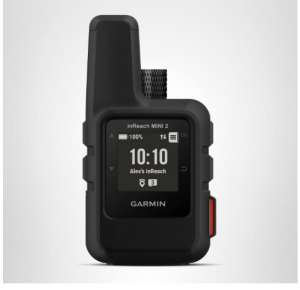
The Garmin inReach Mini 2 is an excellent choice for hikers who venture beyond cellular coverage and need a dependable GPS navigation and satellite communication device. Its compact design, advanced safety features, and global connectivity make it particularly valuable for backpackers, solo hikers, and outdoor adventurers exploring remote trails.
Weighing just 99 grams, it easily fits into a pocket or clips onto a backpack without adding noticeable bulk.
One of the biggest advantages of the Garmin inReach Mini 2 is its ability to provide two-way satellite messaging through the Iridium satellite network. With an active subscription, hikers can send and receive text messages from virtually anywhere in the world, helping them stay connected when traditional communication methods are unavailable.
The device also includes an interactive SOS function that allows users to contact emergency response services in critical situations, providing an extra layer of security during backcountry adventures.
Navigation is another area where this device performs exceptionally well. The TracBack routing feature helps hikers retrace their steps and return to their starting point, reducing the risk of getting lost on unfamiliar trails.
A built-in digital compass delivers accurate heading information even when standing still, making route finding easier in dense forests, mountainous terrain, or low-visibility conditions.
The Garmin inReach Mini 2 works seamlessly with the Garmin Explore app and website, allowing users to plan trips, view topographic maps, create waypoints, and organize routes before heading outdoors. These plans can then be synchronized directly to the device.
The ability to pair with compatible Garmin wearables and handheld GPS units expands its functionality further, enabling message management and emergency communication from connected devices.
Durability and battery performance are well suited for hiking use. The rugged IPX7 water-resistant housing can withstand challenging weather conditions, while the sunlight-readable 1.27-inch transflective display remains easy to view outdoors.
The battery lasts up to 14 days in 10-minute tracking mode, making it suitable for multi-day backpacking trips without frequent recharging.
Customer feedback consistently highlights the unit’s reliability in remote locations and its extremely portable design. Many hikers appreciate the confidence that comes with having access to satellite communication and emergency assistance. Some users note that subscription costs add to the overall expense, and battery performance may vary depending on tracking frequency and usage patterns.
Pros
- Extremely lightweight and compact design
- Global two-way satellite messaging capability
- Interactive SOS emergency response feature
- Reliable TracBack navigation for returning to starting points
- Accurate digital compass works while stationary
- Location sharing through MapShare page
- Seamless integration with Garmin Explore app
- Compatible with Garmin wearables and handheld devices
- Durable IPX7 water-resistant construction
- Long battery life for extended hiking trips
Cons
- Satellite subscription required for messaging and SOS features
For hikers seeking a lightweight GPS navigation device with advanced safety and communication capabilities, the Garmin inReach Mini 2 delivers an impressive combination of navigation, tracking, and emergency preparedness, making it one of the best GPS navigation devices for hiking.
2) ACR ResQLink View
The ACR ResQLink View is a highly dependable emergency beacon that earns its place among the best GPS navigation and safety devices for hiking. Designed for adventurers who explore remote wilderness areas, this compact personal locator beacon focuses on emergency communication and rescue rather than traditional route navigation.
Its lightweight construction and rugged design make it easy to carry on long hikes, backpacking trips, climbing expeditions, and other outdoor adventures where safety is a top priority.
When activated during an emergency, the ACR ResQLink View transmits a distress signal along with your GPS location directly to Search and Rescue authorities worldwide through the 406 MHz emergency distress system.
The device also uses a 121.5 MHz homing signal that helps rescue teams pinpoint your exact location once they are nearby. Unlike many satellite communicators, this beacon does not require a subscription plan for emergency signaling, making it an attractive option for hikers who want reliable protection without recurring service fees.
The device provides truly global coverage through the COSPAS SARSAT satellite network. Because distress alerts are sent directly to official Search and Rescue agencies, there is no need for an intermediate rescue monitoring center.
This direct communication pathway helps ensure that emergency messages reach the appropriate authorities quickly when every minute matters.
The ACR ResQLink View is built for portability and convenience. Its buoyant design prevents it from sinking if dropped in water, while multiple attachment options allow hikers to carry it comfortably on belts, backpacks, life jackets, or outdoor gear. Included clips, straps, and lanyards make it easy to keep the beacon accessible at all times during outdoor activities.
For added functionality, users can subscribe to the optional 406Link testing service. This feature allows the beacon to send non emergency self test and GPS test messages to selected contacts through SMS and email. These messages can include customized text, providing reassurance that the device is functioning properly before heading into the backcountry.
Visibility during rescue situations is enhanced by the inclusion of both a bright LED strobe light and an infrared strobe light. These visual signals improve the likelihood of being located by ground teams, aircraft crews, and search personnel operating in low light conditions or poor weather.
Overall, the ACR ResQLink View is an excellent safety companion for hikers who prioritize emergency preparedness. Its global rescue capabilities, subscription free distress signaling, and durable portable design make it a trusted choice for outdoor enthusiasts venturing far from civilization.
Pros
- No subscription required for emergency distress signaling
- Sends GPS coordinates directly to Search and Rescue agencies worldwide
- Global coverage through COSPAS SARSAT satellite network
- Lightweight and compact for easy carrying
- Rugged and buoyant construction
- Includes multiple attachment clips, straps, and lanyards
- Bright LED strobe light improves visibility during rescue operations
- Infrared strobe light supports additional rescue signaling
- Optional testing service allows messages to be sent to personal contacts
- Reliable emergency communication for remote hiking environments
Cons
- Not designed for turn by turn navigation
3) Garmin Montana® 710, Rugged GPS
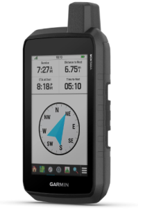
The Garmin Montana® 710 Rugged GPS is a powerful handheld navigation device designed for hikers who need detailed mapping, reliable navigation tools, and exceptional durability. Featuring a large 5 inch glove friendly touchscreen display, it offers excellent visibility in outdoor environments and makes route planning and map viewing much easier than many smaller handheld GPS units.
Whether you are hiking deep into the backcountry, exploring unfamiliar trails, or planning extended expeditions, this device provides the tools needed to stay on course.
The Montana 710 comes preloaded with TopoActive maps, giving hikers access to detailed terrain information right out of the box. Users can further expand its capabilities by downloading additional mapping options, including street navigation maps and marine charts.
The generous 32 GB of internal storage provides plenty of space for extra maps, routes, and navigation data. For hikers who want even more mapping resources, the optional Outdoor Maps+ subscription delivers access to premium mapping content that can be downloaded directly through Wi Fi connectivity.
Navigation accuracy is enhanced through the inclusion of built in ABC sensors. These sensors consist of an altimeter for tracking elevation changes, a barometer for monitoring weather conditions, and a 3 axis electronic compass that provides reliable directional information.
Together, these tools help hikers better understand their surroundings and make informed decisions while on the trail.
One of the most useful features for outdoor exploration is the ability to download high resolution satellite imagery. These photorealistic overhead views allow users to identify landmarks, terrain features, and potential routes with greater confidence.
Waypoints can be created directly from these images, helping hikers mark important locations before or during their adventures.
The Montana 710 is built to handle demanding outdoor conditions. Its rugged construction meets MIL STD 810 standards for thermal resistance, shock resistance, and vibration durability. The device also carries an IPX7 water resistance rating, allowing it to withstand rain, splashes, and harsh weather commonly encountered on hiking trips.
Battery performance is another strong advantage. The rechargeable lithium ion battery delivers up to 24 hours of operation in GPS mode and up to 432 hours in expedition mode. For added flexibility during extended trips, the unit can also operate using traditional AA batteries. Recharging is simple through a standard USB C connection, making it easy to power up from portable battery packs.
Integration with the Garmin Explore smartphone app allows users to plan routes, manage waypoints, organize activities, and review trip data.
The device can also access active weather forecasts through the Garmin Connect app when paired with a compatible smartphone, helping hikers stay informed about changing conditions during their adventures.
Overall, the Garmin Montana 710 combines advanced mapping, rugged durability, long battery life, and versatile navigation tools, making it one of the best GPS navigation devices for hiking enthusiasts who demand reliable performance in challenging outdoor environments.
Pros
- Large 5 inch glove friendly touchscreen display
- Preloaded TopoActive maps for immediate navigation
- Supports additional downloadable maps and charts
- High resolution satellite imagery available
- Built in altimeter, barometer, and electronic compass
- Rugged construction designed for harsh outdoor conditions
- IPX7 water resistant rating
- Large 32 GB storage capacity
- Excellent battery life in both GPS and expedition modes
- Can operate with rechargeable battery or AA batteries
- Compatible with Garmin Explore app for trip planning
- Access to weather forecasts through smartphone connectivity
Cons
- Additional maps and premium content may require extra purchases
4) Garmin GPSMAP H1i Plus
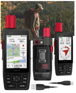
The Garmin GPSMAP H1i Plus is a premium handheld GPS navigator built for hikers who need advanced navigation, satellite communication, and rugged reliability in remote environments. Combining precise GPS performance with inReach Plus satellite technology, this device is designed to keep adventurers connected and informed even when far beyond cellular coverage.
Its feature-rich design makes it an excellent choice for backpackers, mountaineers, and outdoor enthusiasts who frequently explore challenging terrain.
One of the most valuable aspects of the GPSMAP H1i Plus is its built in inReach Plus technology. With an active satellite subscription, users can exchange text messages from virtually anywhere, helping them stay in contact with family, friends, or teammates while exploring remote trails.
The device also allows hikers to capture and share photos and voice messages using the integrated camera and microphone, adding another layer of communication capability rarely found in handheld GPS units.
Safety is a major strength of this navigator. In emergency situations, users can activate an interactive SOS message that connects directly to the Garmin Response international coordination center, which operates around the clock.
This capability provides reassurance for solo hikers and adventurers traveling through isolated wilderness areas where traditional communication methods are unavailable.
Navigation performance is impressive thanks to multi band GPS and multi GNSS support. These technologies work together to deliver highly accurate positioning information, even in environments where satellite reception can be challenging, such as dense forests, deep valleys, or mountainous terrain.
Preloaded TopoActive maps help users navigate trails with confidence, while downloadable high resolution satellite imagery provides detailed visual references for trip planning and route finding.
The device features a bright 3.5 inch sunlight readable touchscreen that remains easy to view outdoors. Its glove friendly design allows hikers to operate the screen without removing gloves, while physical buttons provide additional control in wet or demanding conditions.
The chemically strengthened glass improves durability and helps resist scratches during rugged outdoor use.
Built for adventure, the GPSMAP H1i Plus meets MIL STD 810 standards for thermal resistance, shock resistance, vibration resistance, and water protection with an IP67 rating. This durable construction enables the device to perform reliably in extreme weather and harsh environments.
Integrated front and rear cameras allow users to document their journeys, capture scenery, and even take selfies along the trail.
Additional outdoor focused features further enhance its versatility. The built in flashlight can illuminate dark trails, campsites, and gear, while also functioning as a beacon for signaling assistance when necessary. Voice command support allows users to perform tasks such as checking in, starting tracking sessions, and taking photos without manually navigating menus, making operation more convenient during active adventures.
Battery performance is another area where the GPSMAP H1i Plus excels. It can deliver up to 145 hours of operation in All Satellite Systems plus Multi Band mode with typical SatIQ usage. Expedition mode dramatically extends battery life up to 845 hours, making it suitable for extended wilderness trips where charging opportunities are limited.
Overall, the Garmin GPSMAP H1i Plus combines advanced navigation technology, satellite communication, emergency preparedness, and rugged durability into a single device. For hikers seeking a feature packed GPS navigator that performs well in remote environments, it stands out as one of the best GPS navigation devices for hiking.
Pros
- Built in inReach Plus satellite communication capabilities
- Supports two way text messaging with active subscription
- Interactive SOS emergency assistance feature
- Multi band GPS and multi GNSS support for excellent accuracy
- Preloaded TopoActive maps included
- Supports downloadable satellite imagery
- Bright sunlight readable touchscreen
- Physical buttons improve usability in difficult conditions
- Durable MIL STD 810 and IP67 rated construction
- Integrated front and rear cameras
- Built in flashlight for navigation and signaling
- Voice command functionality enhances convenience
- Exceptional battery life for extended expeditions
- Includes power bank and useful accessories
Cons
- Satellite communication features require an active subscription
5) Garmin Foretrex 401 Waterproof Hiking GPS
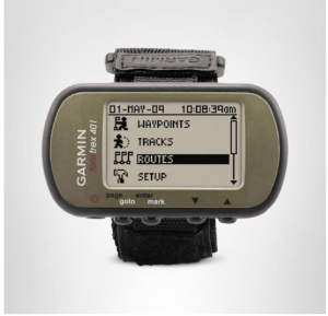
The Garmin Foretrex 401 Waterproof Hiking GPS is a compact and highly dependable navigation device designed for hikers, hunters, military personnel, and outdoor adventurers who value simplicity and reliability.
Worn comfortably on the wrist, it provides accurate GPS navigation without the bulk of larger handheld units. Its rugged construction, straightforward operation, and proven performance in challenging environments make it one of the best GPS navigation devices for hiking.
The Foretrex 401 uses a high sensitivity GPS receiver with HotFix technology, allowing it to acquire satellite signals quickly and maintain strong reception even under dense tree canopies or within deep canyons. This capability is particularly useful for hikers who frequently travel through forests, mountainous terrain, or remote wilderness areas where GPS reception can be more challenging.
Navigation features are focused on practical outdoor use. The device stores routes, tracks, and waypoints, helping hikers record their journeys and return to important locations.
The TracBack function allows users to retrace their exact path back to the starting point by following recorded tracks displayed on the LCD screen. This feature can be extremely valuable when navigating unfamiliar trails or returning to camp after a long day of hiking.
Another useful capability is the dual position readout system, which allows users to view their location in multiple coordinate formats simultaneously. This flexibility is helpful when working with printed maps, shared coordinates, or navigation data obtained from different sources. Users can also manually enter coordinates to navigate directly to specific destinations.
The Foretrex 401 includes several sensors that improve situational awareness during outdoor adventures. An electronic compass provides directional guidance, while a barometric altimeter tracks elevation changes and helps monitor climbing progress.
Additional outdoor tools include sunrise and sunset information, hunting and fishing data, and a trip computer that displays speed, maximum speed, distance traveled, and other useful statistics.
Its compact LCD display measures 1.42 by 0.91 inches and offers a resolution of 100 x 64 pixels. While simple by modern standards, the display is easy to read and designed for efficient outdoor navigation. The unit weighs only 3.1 ounces, making it one of the lightest GPS navigation devices available for hikers who want to minimize pack weight.
Durability is one of the Foretrex 401’s strongest qualities. The device features an IPX7 waterproof rating and is widely trusted in demanding environments. Its rugged construction allows it to withstand rain, mud, and harsh outdoor conditions, making it well suited for extended hiking trips and wilderness expeditions.
Power comes from two standard AAA batteries, which are easy to replace in the field. Battery life can reach up to 17 hours in GPS mode, although heavy continuous tracking may reduce operating time. The ability to carry spare batteries provides flexibility for longer trips where charging options are unavailable.
Customer feedback is overwhelmingly positive regarding functionality, hiking performance, and ease of use. Many users appreciate its reliable GPS accuracy, durable design, and lightweight wrist mounted format.
While it lacks advanced mapping and communication features found in newer devices, it remains a trusted navigation companion for hikers who prioritize dependable tracking and navigation over extra technology.
Pros
- High sensitivity GPS receiver with HotFix technology
- Performs well under tree cover and in deep canyons
- Lightweight and comfortable wrist mounted design
- TracBack feature helps return to starting point
- Stores routes, tracks, and waypoints
- Dual position coordinate display options
- Electronic compass and barometric altimeter included
- Useful trip computer functions
- Sunrise, sunset, hunting, and fishing information
- Waterproof IPX7 rated construction
- Uses easily replaceable AAA batteries
- Compact and highly durable design
- Strong customer ratings for hiking and outdoor use
Cons
- No downloadable maps
6) Magellan Triton 1500 Waterproof Hiking GPS
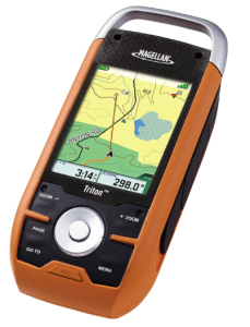
The Magellan Triton 1500 Waterproof Hiking GPS is a feature rich handheld navigator that was designed to bring navigation, multimedia, and outdoor convenience together in a single device. Although it is an older model, it remains an interesting option for hikers who appreciate innovative technology and a unique combination of navigation and entertainment features.
When introduced, it gained attention as the world’s first handheld GPS device equipped with a touchscreen display, helping set the stage for many of the GPS units that followed.
The Triton 1500 features a 2.7 inch full color touchscreen display with a resolution of 480 x 272 pixels. The screen provides a more interactive navigation experience than many handheld GPS units available at the time of its release.
Touch controls simplify menu navigation, while microphone input adds another layer of user interaction. The device supports topographical mapping for North America and allows users to enter coordinates manually for overland navigation and route planning.
For hikers exploring trails and wilderness areas, the GPS functionality helps track locations and navigate routes with confidence. The unit is also compatible with wrist mounting systems, allowing users to keep navigation information easily accessible while hiking, climbing, or participating in outdoor activities.
One of the more unusual features of the Triton 1500 is its multimedia capability. Users can store and view photos, listen to MP3 music files, and enjoy audiobooks during downtime at camp or while relaxing after a long day on the trail.
The integrated speaker and microphone make it possible to record audio notes, observations, or trip memories directly on the device, which can be useful for documenting outdoor adventures.
Safety and convenience are enhanced by the built in LED flashlight. This feature can help illuminate trails, campsites, gear, or maps when darkness falls. While simple, the flashlight adds practical value for hikers who spend time outdoors after sunset.
Storage capacity is generous for a device of its era. With 16 GB of internal memory, users can store maps, terrain data, photos, audio files, and other information without quickly running out of space. Additional mapping resources can also be added, helping expand the device’s navigation capabilities beyond its standard configuration.
The waterproof construction helps protect the unit from rain and wet outdoor conditions, making it suitable for hiking and other outdoor activities. It operates on two AA batteries and can provide up to 10 hours of battery life under normal usage conditions.
The use of replaceable batteries allows hikers to carry spares for longer trips where charging options are unavailable.
Customer feedback highlights the Triton 1500’s solid build quality and innovative feature set. Many users appreciated its touchscreen technology and multimedia functions. However, some owners reported software stability issues, including occasional freezing or lockups.
Others found the menu system somewhat complicated and noted that screen visibility could be challenging in bright sunlight. Since this device was released in 2007, map availability and manufacturer support may also be more limited compared to current GPS models.
Overall, the Magellan Triton 1500 remains an interesting waterproof hiking GPS that combines navigation, multimedia entertainment, and practical outdoor tools. While newer GPS devices offer more advanced technology, the Triton 1500 still appeals to users looking for a multifunctional hiking companion with a distinctive feature set.
Pros
- Innovative touchscreen interface for a handheld GPS device
- Full color 2.7 inch display
- Supports topographical mapping and coordinate navigation
- Can display photos and play MP3 files
- Supports audiobook playback
- Built in speaker and microphone for audio recording
- Integrated LED flashlight for nighttime use
- Generous 16 GB internal storage
- Waterproof construction for outdoor activities
- Uses easily replaceable AA batteries
- Wrist mount compatibility for convenient carrying
- Solid construction praised by many users
Cons
- Older device with limited manufacturer support
7) Bushnell GPS BackTrack Personal Locator
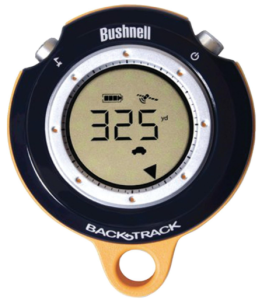
The Bushnell GPS BackTrack Personal Locator is a simple and lightweight navigation device designed for hikers, campers, hunters, and travelers who want an easy way to find their way back to important locations.
Rather than offering complex mapping features, this compact GPS focuses on a straightforward purpose: helping users mark locations and navigate back to them when needed. Its simplicity makes it an appealing option for outdoor enthusiasts who prefer basic navigation without a steep learning curve.
The device uses a high sensitivity SiRF Star III GPS receiver that performs reasonably well in outdoor environments, including areas with moderate tree cover. Users can save up to three locations, making it useful for marking a parked vehicle, campsite, trailhead, hunting stand, or other important points of interest. Once a location is stored, the BackTrack displays both the distance and direction needed to return to that point.
Navigation information is presented on an easy to read screen that displays directional arrows and distance measurements. The minimal button layout keeps operation simple and intuitive, allowing most users to learn the device quickly.
This straightforward approach is one reason many hikers and campers appreciate the BackTrack, especially those who do not need detailed maps or advanced navigation functions.
A self calibrating digital compass helps provide directional guidance during navigation. Combined with GPS positioning, it assists users in orienting themselves and following the correct route back to a saved waypoint.
The compact design allows the device to fit easily into a pocket, backpack pouch, or small gear compartment, making it convenient to carry on day hikes and outdoor excursions.
The weather resistant construction helps protect the unit from light rain and outdoor conditions commonly encountered during hiking trips. A lanyard is included, making it easy to attach the device to a backpack, belt loop, or gear bag for quick access when needed.
Power is supplied by two AAA batteries, which are easy to replace in the field. Battery life can reach up to 20 hours under normal use, providing enough operating time for most day hikes and weekend adventures. The use of standard batteries eliminates the need for charging equipment and allows users to carry spare batteries for extended outings.
Customer feedback is generally positive regarding functionality and ease of use. Many users find it effective for hiking, camping, hunting, and travel applications. The device is often praised for its simplicity, affordability, and ability to perform its primary task effectively.
Some users, however, report occasional inconsistencies in directional guidance and note that satellite acquisition can sometimes take longer than expected.
It is important to understand that the Bushnell GPS BackTrack Personal Locator is not a full featured hiking GPS. It does not include maps, trail routing, wireless connectivity, or satellite communication capabilities. Additionally, the product line has been discontinued, which may limit repair options and manufacturer support.
Overall, the Bushnell GPS BackTrack Personal Locator remains a practical navigation tool for hikers who want a compact and easy to use device for marking locations and finding their way back. Its lightweight design, straightforward functionality, and reliable waypoint navigation make it a useful companion for basic outdoor adventures.
Pros
- Simple and beginner friendly operation
- Stores up to three important locations
- Displays distance and direction to saved waypoints
- High sensitivity SiRF Star III GPS receiver
- Self calibrating digital compass included
- Compact and lightweight design
- Weather resistant construction
- Easy to carry in a pocket or backpack
- Includes lanyard for convenient attachment
- Operates on standard AAA batteries
- Up to 20 hours of battery life
- Highly rated for functionality and ease of use
Cons
- No mapping capabilities
Next read: 9 Best Handheld GPS Navigation Devices
Factors To Consider When Choosing The Best GPS Navigation Devices For Hiking
1. Navigation Accuracy
Accuracy is one of the most important factors when selecting a hiking GPS device. A reliable unit should maintain a strong satellite connection and provide precise location data, even in challenging environments such as dense forests, deep valleys, or mountainous terrain.
Devices that support multiple satellite systems and advanced positioning technologies typically offer better tracking performance and help reduce navigation errors during outdoor adventures.
2. Mapping Capabilities
The quality of maps available on a GPS device can greatly impact your hiking experience. Some units offer detailed topographic maps, satellite imagery, and downloadable mapping options, while others provide only basic waypoint navigation.
Hikers who frequently explore unfamiliar terrain should prioritize devices with detailed mapping support, as these features make route planning and navigation significantly easier.
3. Battery Life
Battery performance becomes especially important during long hikes, backpacking trips, and multi day expeditions. A GPS device should provide enough operating time to last throughout your adventure without frequent recharging.
Some models use rechargeable batteries, while others rely on replaceable batteries that can be swapped in the field. Choosing a device with strong battery endurance helps ensure continuous navigation when it matters most.
4. Durability and Weather Resistance
Outdoor environments can be unpredictable, making durability a critical consideration. A quality hiking GPS should be able to withstand rain, dust, accidental drops, temperature changes, and rough handling. Water resistance ratings and rugged construction standards provide additional confidence that the device will continue functioning in harsh conditions encountered on the trail.
5. Size and Portability
The ideal GPS device should balance functionality with portability. Lightweight and compact models are easier to carry during long hikes and reduce the overall weight of your gear. Larger devices may offer bigger screens and more advanced features, but they can also add bulk. Choosing a size that matches your hiking style helps improve comfort and convenience.
6. Safety and Emergency Features
Many modern GPS devices include safety tools that can be invaluable in remote areas. Features such as emergency SOS signaling, location sharing, satellite communication, and tracking functions can provide additional security when hiking beyond cellular coverage.
These capabilities can help hikers stay connected and improve emergency response options when unexpected situations arise.
7. Ease of Use
A GPS device should be simple to operate, especially when navigating difficult terrain or adverse weather conditions. Clear menus, intuitive controls, responsive touchscreens, and easy to read displays contribute to a better user experience.
Devices that require minimal training allow hikers to focus on the trail rather than spending time navigating complicated settings.
8. Additional Navigation Sensors and Features
Many hiking GPS units include extra tools that improve outdoor navigation and situational awareness. Features such as electronic compasses, barometric altimeters, weather forecasting, waypoint management, route tracking, and trip computers can provide valuable information during a hike.
Evaluating which additional features align with your hiking needs can help you choose a device that offers the best overall value.
Next read: 7 Best Holo Sights With Magnifier
Advantages Of Using GPS Navigation Devices For Hiking
1. Accurate Navigation in Remote Areas
One of the biggest advantages of using a GPS navigation device for hiking is the ability to accurately determine your location, even in remote areas where trails may be poorly marked or completely absent. By receiving signals from satellites, these devices help hikers identify their position with a high level of precision, reducing the chances of becoming lost while exploring unfamiliar terrain.
2. Increased Safety on the Trail
GPS navigation devices provide an added layer of safety during outdoor adventures. Many models include emergency features such as location tracking, SOS signaling, and route recording. These capabilities can be extremely valuable when hiking alone, traveling through isolated wilderness, or encountering unexpected situations that require assistance.
3. Easy Route Tracking
A GPS device continuously records your movements throughout a hike, creating a track log of your journey. This allows you to review your route, monitor progress, and retrace your steps if necessary. Having a recorded path is particularly useful when navigating complex trail networks or returning to a starting point after exploring off trail areas.
4. Better Trip Planning
Many GPS navigation devices support route creation, waypoint management, and map downloads. These features allow hikers to plan their trips in advance by identifying trails, campsites, water sources, and points of interest.
Proper planning can improve efficiency, reduce uncertainty, and help hikers prepare for changing terrain and conditions.
5. Reliable Performance Without Cellular Service
Unlike smartphones that often rely on mobile networks for navigation, dedicated GPS devices continue to function in areas without cellular coverage. This makes them especially valuable for backcountry hiking, mountain adventures, and wilderness expeditions where mobile signals may be weak or unavailable.
6. Access to Detailed Mapping Information
Many hiking GPS devices offer topographic maps, elevation data, satellite imagery, and terrain information. These resources help hikers better understand their surroundings and make informed navigation decisions. Detailed maps can also assist with identifying alternative routes, natural landmarks, and potential hazards along the trail.
7. Enhanced Outdoor Awareness
GPS devices often include additional navigation tools such as electronic compasses, altimeters, barometers, and trip computers. These features provide valuable information about direction, elevation changes, weather trends, speed, and distance traveled. Access to this data helps hikers maintain awareness of their environment throughout their journey.
8. Improved Confidence for Exploring New Trails
Knowing that accurate navigation assistance is readily available gives hikers greater confidence when exploring unfamiliar destinations. Instead of worrying about losing their way, hikers can focus on enjoying the scenery, discovering new routes, and expanding their outdoor experiences with greater peace of mind.
9. Convenient Waypoint Marking
GPS navigation devices allow users to save important locations such as trailheads, campsites, parking areas, water sources, scenic viewpoints, and emergency exit points. These saved waypoints can be revisited later, making navigation more efficient and helping hikers quickly locate key destinations during their trips.
10. Useful for Long Distance and Multi Day Adventures
For extended hiking trips, backpacking expeditions, and wilderness treks, GPS navigation devices provide dependable guidance over long periods.
Their ability to store routes, maps, and location data helps hikers remain on course throughout lengthy journeys while reducing reliance on paper maps alone.
11. Durability in Harsh Outdoor Conditions
Dedicated hiking GPS devices are generally built to withstand challenging outdoor environments. Many are resistant to water, dust, shocks, and extreme temperatures. This rugged construction makes them more reliable than many consumer electronics when exposed to rain, rough terrain, and demanding weather conditions.
12. Emergency Preparedness
A GPS navigation device can play an important role in emergency situations. Whether it is helping rescuers locate your position, guiding you back to safety, or providing communication options in remote areas, these devices contribute significantly to overall preparedness. For hikers venturing far from civilization, this added security can be invaluable.
Best GPS Navigation Devices For Hiking FAQs
1. Do I need a GPS navigation device if I already have a smartphone?
A smartphone can be useful for navigation, but a dedicated GPS navigation device offers several advantages for hiking. GPS units are typically more rugged, have longer battery life, provide better performance in remote areas, and continue working without cellular service.
Many are also designed to withstand harsh weather conditions, making them a more dependable choice for serious outdoor adventures.
2. What features should I look for in a hiking GPS device?
The most important features include accurate GPS tracking, detailed mapping capabilities, long battery life, durable construction, water resistance, and an easy to read display. Some hikers may also benefit from additional features such as satellite communication, emergency SOS functions, electronic compasses, altimeters, weather updates, and route planning tools depending on their hiking style and destinations.
3. Can GPS navigation devices work without an internet connection?
Yes. Dedicated GPS navigation devices receive location information directly from satellites and do not require an internet connection to determine your position. As long as maps are preloaded or downloaded beforehand, hikers can navigate confidently in remote areas where mobile networks and internet access are unavailable.
Conclusion
In conclusion, the best GPS navigation devices for hiking provide a reliable combination of accurate positioning, dependable route tracking, detailed mapping, and rugged durability that can significantly enhance any outdoor adventure.
Whether I’m hiking local trails, exploring remote wilderness areas, or embarking on extended backpacking trips, these devices help me stay on course, monitor my progress, and navigate with greater confidence. Many models also offer valuable features such as electronic compasses, altimeters, weather information, waypoint management, and emergency communication capabilities that improve both convenience and safety.
By choosing a GPS navigation device that matches my hiking style, terrain, and navigation needs, I can enjoy a safer, more efficient, and more enjoyable experience on every trail.