
Table of Contents
ToggleWhen I look at the best drones with a thermal camera, I see powerful tools that go far beyond standard aerial photography. These drones are great because they can detect heat signatures, operate in complete darkness, and reveal details that the human eye simply cannot see.
Whether it is for search and rescue, inspections, security, or mapping, thermal imaging adds a whole new level of precision and efficiency. In this guide, I will walk through the key features that matter most, highlight some of the top options available, and provide a helpful buying guide along with frequently asked questions to make choosing the right thermal drone much easier.
Best Drones With Thermal Camera
1) Autel Robotics EVO MAX 4T V2
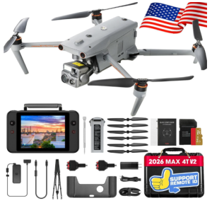
The Autel Robotics EVO MAX 4T V2 stands out as one of the best drones with a thermal camera, designed for professionals who need reliability, precision, and advanced imaging in demanding environments. It combines multiple powerful sensors into one platform, giving users the ability to capture detailed visuals, measure distances, and detect heat signatures with impressive accuracy. This makes it especially useful for applications like search and rescue, industrial inspections, and security operations.
This drone features a highly capable imaging system that includes a 48MP wide-angle camera with a 1/2-inch CMOS sensor and ISO up to 64000. Low-light performance is enhanced through Moonlight Algorithm 2.0, allowing clear image capture even in dim conditions.
Alongside this, the 48MP zoom camera supports 8K video and 10x optical zoom, extending up to 160x maximum zoom for long-distance observation. The integrated thermal camera delivers 640 by 512 resolution at 30Hz with a 9.1mm focal length and 16x digital zoom, enabling precise heat detection across a wide range of scenarios. A built-in laser rangefinder further improves operational efficiency by measuring distances from approximately 16.4 to 3737 feet with high accuracy.
The updated V2 version introduces design improvements that enhance both performance and safety. The drone now features optimized fisheye lens positioning and improved navigation light placement, which strengthens obstacle detection.
Additional side grooves help with heat dissipation during extended flights. The included ABX41-D battery supports hot swapping, allowing continuous operation without long downtime. It also includes a battery detection system that alerts users if the battery is not securely installed, reducing the risk of unexpected power loss.
Autonomy is a major strength of this drone. It supports advanced navigation features such as automatic pathfinding, real-time 3D flight path creation, and operation in GPS-denied environments. The drone can identify and track objects accurately, even in complex surroundings. Its multi-sensor fusion system combines dual fisheye vision with millimeter-wave radar, delivering full 720-degree obstacle avoidance. This ensures safer flights in challenging environments such as near water, dense structures, or power lines.
Connectivity and reliability are also well addressed. The drone uses advanced anti-interference technology to handle radio frequency interference, electromagnetic interference, and GPS spoofing. This allows it to operate confidently in sensitive or high-risk areas.
A-Mesh networking technology enables multiple devices to connect and work together, creating a broader and more efficient operational network. This is particularly useful for beyond visual line of sight missions and coordinated team operations.
The EVO MAX 4T V2 also supports a wide range of mission types, including waypoint navigation, polygon mapping, and aerial surveying. Users can easily export captured data for 2D and 3D modeling, making it a strong choice for mapping and inspection tasks. Dual-controller support allows for zonal operations, where multiple users can monitor and control the drone simultaneously. Information such as AI target recognition and pinpoint positioning can be shared across controllers, improving coordination and efficiency.
Pros
- Clear multi-sensor system combining thermal, zoom, wide camera, and rangefinder
- Strong low-light imaging performance
- High-resolution thermal camera with reliable detection
- Advanced obstacle avoidance with full coverage
- Operates in GPS-denied environments
- Hot-swappable battery improves workflow efficiency
- Reliable anti-interference and networking capabilities
- Supports multiple mission types for professional use
Cons
- Premium price may not suit casual users
2) Autel Robotics EVO II

The Autel Robotics EVO II Dual 640T Enterprise V3 is a highly capable option among the best drones with a thermal camera, designed for professionals who need dependable imaging and versatile performance across different industries.
From public safety to inspections and search operations, this drone combines thermal intelligence with high-resolution visual capture, giving users the tools needed for detailed analysis and efficient decision-making in the field.
One of its strongest capabilities lies in its thermal imaging system. It features a 640 by 512 resolution thermal sensor with a 13mm focal length and 16x digital zoom, allowing users to detect and observe targets at a distance with impressive clarity.
The updated image processing algorithm enhances thermal detail, making it easier to identify subjects, monitor activity, and analyze environments. With multiple temperature measurement modes such as spot, regional, and alarm settings, users can perform precise thermal assessments. The inclusion of various color palettes and support for thermal analysis software also makes post-processing and reporting more efficient.
In addition to thermal performance, the drone offers a powerful 50MP visual camera equipped with a 0.8 inch RYYB sensor. Combined with Moonlight Algorithm 2.0, it delivers excellent low-light performance with reduced noise and improved clarity.
This makes it suitable for nighttime operations or dim environments where detail is critical. The dual camera system allows users to switch between thermal and visual views or combine them for better situational awareness during missions.
The EVO II Dual 640T Enterprise V3 is built for flexibility in real-world applications. It supports a range of accessories including a spotlight, loudspeaker, and strobe, allowing it to adapt to different operational needs. Whether it is used for search and rescue, traffic monitoring, power line inspection, or mapping, the drone provides consistent performance. Its compatibility with additional modules such as RTK further expands its capabilities for precise positioning and surveying tasks.
Connectivity and transmission are handled through Autel SkyLink 2.0, which enables HD video transmission up to 15 kilometers. Within closer range, users can access high-quality QHD video for detailed observation.
The tri band communication system automatically switches frequencies to reduce interference, ensuring stable and reliable connections even in challenging environments. This is especially useful for missions that require uninterrupted live feeds and accurate control.
The included Smart Controller V3 enhances the overall user experience with a bright 7.9 inch display that remains clearly visible even under direct sunlight. With a brightness level significantly higher than typical mobile devices, it ensures pilots can maintain full control and visibility in outdoor conditions. The intuitive interface and responsive touch screen contribute to smooth operation, making it easier to manage complex missions.
Pros
- High resolution thermal imaging with clear detail
- Multiple temperature measurement modes for accurate analysis
- Strong low light performance from the 50MP camera
- Reliable long range video transmission
- Flexible accessory support for different mission needs
- Bright and responsive smart controller display
- Suitable for a wide range of professional applications
- Comprehensive bundle with useful additional equipment
Cons
- Premium pricing may not suit casual users
3) Autel Robotics EVO MAX 4N V2

The Autel Robotics EVO MAX 4N V2 is a powerful addition to the category of the best drones with a thermal camera, especially for users who require advanced night operations and high-level situational awareness. Built for professional use, this drone combines thermal imaging, starlight vision, and precision measurement tools into a single platform, making it highly effective for security, surveillance, inspections, and emergency response missions.
This drone brings together a sophisticated multi-sensor system designed to perform in both daylight and complete darkness. It includes a starlight camera with extreme light sensitivity, capable of capturing clear visuals even in near-total darkness.
The 50MP wide camera with a 1 over 1.28 inch CMOS sensor and bright aperture ensures detailed daytime imaging, while the thermal camera offers 640 by 512 resolution with a 9.1mm focal length and 16x digital zoom.
This allows accurate temperature detection across a wide range, making it useful for identifying heat sources in various environments. A built-in laser rangefinder with a measuring range of 5 to 1200 meters adds another layer of precision for distance estimation and field analysis.
Night performance is a major strength of this drone. The starlight vision system is not limited by lighting conditions or temperature differences, allowing it to see clearly even through obstacles such as glass. It can detect small light sources like mobile phones or vehicle lights from long distances, making it ideal for covert monitoring and reconnaissance tasks. This capability significantly enhances visibility in scenarios where traditional cameras would struggle.
The V2 update introduces practical design and safety improvements. The drone features optimized fisheye lens placement and navigation lighting to improve obstacle awareness. Additional ventilation grooves help maintain stable performance by improving heat dissipation.
The ABX41 D battery supports hot swapping, allowing users to replace batteries without powering down the system. It also includes a detection feature that alerts users if the battery is not properly installed, helping to prevent unexpected shutdowns.
Flight reliability is enhanced through strong anti interference technology. The drone is built to counter radio frequency interference, electromagnetic interference, and GPS spoofing, allowing it to operate safely in complex environments such as near infrastructure or in signal challenged areas. It also features A Mesh 1.0 networking, enabling multiple drones to communicate and collaborate. This system can self organize if one unit fails, ensuring continuous data transmission during critical missions.
Obstacle avoidance is highly advanced, combining binocular vision systems with millimeter wave radar technology. This setup enables detection of very small objects and removes blind spots, even in low light or adverse weather conditions. The drone can navigate complex environments such as forests or mountainous terrain while maintaining stable flight and accurate positioning, even without GPS.
Connectivity is powered by SkyLink 3.0, offering a transmission range of up to 20 kilometers with low latency and high quality real time video. The system uses multiple frequency bands and encryption for secure and stable communication. The included Smart Controller V3 features a bright 7.9 inch display, ensuring clear visibility even under strong sunlight, which improves control and monitoring during operations.
Pros
- Excellent night vision capabilities with starlight camera
- High resolution thermal imaging for accurate detection
- Strong multi sensor system for diverse data capture
- Reliable long range transmission with low latency
- Advanced obstacle avoidance with no blind spots
- Operates effectively in GPS denied environments
- Hot swappable battery improves efficiency
- Durable design with improved heat management
- Supports collaborative operations with mesh networking
Cons
- High price point for professional use
4) Autel Robotics EVO Lite 640T Enterprise Bundle

The Autel Robotics EVO Lite 640T Enterprise Bundle is a compact yet capable option among the best drones with a thermal camera, designed for professionals who need portability without sacrificing performance.
With its lightweight foldable design and intuitive controls, it is ideal for single-operator missions in fields such as public safety, inspections, and emergency response. Despite its smaller size, it delivers reliable thermal imaging and intelligent features that make it a practical tool for real-world operations.
This drone is equipped with a high-resolution thermal camera that captures data at 640 by 512 resolution at 30Hz. It includes a 9mm lens and supports up to 16x digital zoom, allowing users to detect and analyze heat sources with clarity.
The system can measure temperatures ranging from minus 20 degrees Celsius to 550 degrees Celsius with solid accuracy, making it suitable for identifying heat anomalies in critical scenarios. Whether used for search and rescue or equipment inspections, the thermal capabilities provide dependable results.
Alongside thermal imaging, the drone features a 48MP visible light camera with a 1 over 2 inch CMOS sensor. This allows it to capture detailed images for documentation and analysis, even in demanding environments.
The combination of thermal and visual imaging helps users gain a complete understanding of the scene, improving decision making during operations. The camera system also supports digital zoom, extending its usability in situations that require closer observation from a safe distance.
Intelligence features further enhance its performance. The AI target recognition system can identify and track objects, improving over time through a self-learning process. It can display recognized targets on a digital map in real time, supporting the tracking of multiple subjects simultaneously. This is particularly useful for search and rescue missions, surveillance tasks, and coordinated field operations where situational awareness is essential.
The drone works seamlessly with the Autel Enterprise app, offering a user friendly interface that simplifies mission planning and execution. It is designed for efficient single pilot deployment, reducing the need for large teams in the field.
SkyLink 2.0 transmission technology ensures stable communication with a range of up to 12 kilometers, along with improved resistance to signal interference. This provides consistent video feeds and control even in complex environments.
Its lightweight build of just 866 grams and foldable structure make it easy to transport and deploy quickly. The included bundle adds extra value with spare batteries, propellers, and essential accessories, allowing users to stay operational for longer periods without interruption.
Pros
- Lightweight and portable design for easy transport
- High resolution thermal imaging with accurate temperature measurement
- Detailed 48MP visible camera for clear documentation
- AI target recognition with real time tracking capabilities
- User friendly operation suitable for single pilot missions
- Reliable transmission with good range and stability
- Comes with useful accessories for extended use
Cons
- Digital zoom instead of optical zoom may limit detail at distance
5) Autel Robotics EVO II PRO RTK V3

The Autel Robotics EVO II Pro RTK V3 is a highly capable professional drone that earns its place among the best drones with a thermal camera category alternatives, particularly for users focused on mapping, surveying, and precision data collection.
While it emphasizes high-accuracy positioning and advanced imaging rather than integrated thermal sensing, it remains a strong choice for professionals who require dependable performance and detailed aerial data for complex missions.
One of its most impressive capabilities is the RTK positioning system, which delivers centimeter-level accuracy in real time. With positioning precision down to approximately 1 cm horizontally and 1.5 cm vertically, this drone provides highly reliable geospatial data.
It supports both RTK base stations and RTK networks, allowing it to maintain stable and accurate positioning even in challenging environments. This level of accuracy is especially valuable for mapping, construction planning, and land surveying where precision is critical.
The drone is designed to handle automated mission execution with ease. Users can create detailed flight paths such as waypoint routes, rectangular grids, polygon missions, and oblique photography plans. Once configured, the drone follows the designated route autonomously, ensuring consistent and repeatable data collection. It also has the ability to replicate previous flight missions, including camera angles and movements, which is useful for tracking changes over time or maintaining consistency across multiple surveys.
Another key advantage is its ability to operate without the need for ground control points in many scenarios. With support for both RTK and PPK workflows along with time synchronization, it simplifies the mapping process and reduces setup time in the field. This makes it more efficient for professionals who need to complete projects quickly while maintaining accuracy.
The EVO II Pro RTK V3 is also built for versatility across industries. It performs well in applications such as mapping, environmental monitoring, firefighting support, infrastructure inspection, and law enforcement operations.
Its compatibility with software tools for generating point clouds, orthomosaics, and CAD models further enhances its usefulness for technical workflows. This allows users to transform aerial data into actionable insights with minimal friction.
The included bundle adds value by providing multiple batteries, a smart controller, chargers, and protective accessories. This ensures users can stay operational for longer sessions without needing additional purchases. The system is also designed to be user friendly, making it accessible to professionals who want powerful features without overly complicated controls.
Pros
- Extremely accurate RTK positioning for precise data collection
- Supports automated and repeatable flight missions
- No need for ground control points in many workflows
- Compatible with professional mapping and modeling software
- Reliable performance across multiple industries
- Comprehensive bundle with essential accessories
- Efficient workflow for surveying and inspection tasks
Cons
- Does not include a built in thermal camera
Next read: 8 Best Smart Baby Monitors For Car
Factors To Consider When Choosing The Best Drones With Thermal Camera
Choosing the best drone with a thermal camera requires careful evaluation of several important factors to ensure it meets your specific needs and performs reliably in real-world conditions.
1. Thermal Camera Resolution and Quality
The resolution of the thermal sensor determines how much detail you can capture. Higher resolutions provide clearer images, making it easier to detect heat differences and identify objects accurately. This is especially important for tasks like inspections, search operations, and surveillance where precise thermal data is essential. Frame rate and image processing also influence how smooth and detailed the thermal output appears.
2. Temperature Measurement Accuracy and Range
A good thermal drone should offer reliable temperature readings across a wide range. Accurate measurement is critical for identifying heat anomalies, monitoring equipment, or assessing environmental conditions. Look for systems that provide consistent readings with minimal deviation, along with multiple measurement modes such as spot, area, and alarm-based detection for more flexibility.
3.Camera System Versatility
Many thermal drones include additional cameras such as wide-angle or zoom lenses. Having multiple imaging options allows you to switch between thermal and visual perspectives or combine them for better situational awareness. This is particularly useful when you need both detailed visuals and heat data to fully understand a scene.
4.Flight Performance and Stability
Stable flight is essential for capturing clear images and maintaining control in different environments. Factors such as wind resistance, hover stability, and overall build quality affect how well the drone performs. A reliable drone should remain steady during flight, even in challenging conditions, to ensure consistent data capture.
5.Obstacle Avoidance and Navigation
Advanced obstacle detection systems help prevent collisions and improve safety. Features such as multi-directional sensing and intelligent navigation allow the drone to operate in complex environments like forests, urban areas, or near structures. Some drones can even function in GPS-limited areas, which is valuable for indoor or obstructed operations.
6.Transmission Range and Signal Reliability
A strong and stable connection between the drone and controller is crucial for real-time monitoring and control. Longer transmission ranges allow you to cover more ground, while anti-interference technology ensures consistent performance in areas with signal disruption. Low latency is also important for responsive control and accurate decision-making.
7. Battery Life and Operational Efficiency
Flight time directly impacts how much work you can complete in a single session. Longer battery life reduces interruptions and increases productivity. Features like fast charging or battery swapping can further improve efficiency, especially during extended missions where downtime needs to be minimized.
8. Intelligent Features and Software Integration
Modern thermal drones often include smart features such as automated flight paths, object tracking, and AI-based detection. These tools simplify complex tasks and improve overall efficiency. Integration with mapping or analysis software also allows users to process data, generate reports, and gain deeper insights from captured information.
Next read: 7 Best Thermal Imaging Cameras For Hunting
Advantages Of Using Drones With Thermal Camera
Drones with thermal cameras offer a wide range of benefits across industries, making them valuable tools for both professional and specialized applications.
1. Enhanced Visibility in Low Light and Darkness
Thermal drones can detect heat instead of relying on visible light, which allows them to operate effectively in complete darkness or poor lighting conditions. This makes them ideal for nighttime surveillance, search missions, and security operations where traditional cameras would struggle to capture usable images.
2. Improved Detection of Heat Signatures
These drones can identify temperature differences that are invisible to the human eye. This ability is crucial for locating people, animals, or overheating equipment. It also helps in identifying hidden issues such as electrical faults, insulation gaps, or leaks, making inspections faster and more accurate.
3.Increased Efficiency in Search and Rescue Operations
Thermal imaging significantly speeds up search and rescue efforts by helping locate individuals based on body heat, even in challenging environments like forests, mountains, or disaster zones. This reduces search time and increases the chances of successful outcomes, especially in time-sensitive situations.
4.Safer Inspections in Hazardous Environments
Using a drone with a thermal camera allows operators to inspect dangerous areas from a safe distance. This includes power lines, industrial equipment, fire zones, and unstable structures. It minimizes the need for human exposure to risks while still providing detailed and reliable data.
5.Accurate Temperature Measurement and Monitoring
Thermal drones can measure and monitor temperature changes in real time. This is useful in applications such as firefighting, equipment maintenance, and environmental monitoring. Early detection of abnormal temperature patterns can help prevent failures, reduce downtime, and improve safety.
6.Greater Situational Awareness
By combining thermal imaging with aerial perspectives, these drones provide a comprehensive view of a scene. Operators can quickly assess large areas and identify areas of concern without needing to physically access the location. This improves decision-making and operational planning.
7.Cost and Time Savings
Deploying thermal drones can reduce the need for manual inspections, large teams, or expensive equipment. Tasks that would normally take hours or days can be completed much faster, leading to lower operational costs and improved productivity over time.
8.Versatility Across Multiple Industries
Thermal drones are used in a wide range of fields, including public safety, agriculture, construction, wildlife monitoring, and infrastructure inspection. Their ability to adapt to different tasks makes them a flexible investment for organizations that require reliable data collection and analysis in various scenarios.
Best Drones With Thermal Camera FAQs
1. What are drones with thermal cameras used for?
Drones with thermal cameras are used to detect heat differences in various environments, making them valuable for tasks such as search and rescue, security surveillance, firefighting support, and industrial inspections. They help identify people, animals, or equipment issues that may not be visible with standard cameras, especially in low-light or complex conditions.
2. How accurate are thermal cameras on drones?
Thermal cameras on drones are generally quite accurate, especially in professional-grade models. They can measure temperature differences within a small margin of error and provide reliable data for analysis. Accuracy depends on factors such as sensor quality, calibration, and environmental conditions, but most modern systems offer consistent performance for practical applications.
3. Can thermal drones be used in complete darkness or bad weather?
Yes, thermal drones can operate effectively in complete darkness because they rely on heat detection rather than visible light. Many are also designed to handle challenging conditions such as fog, smoke, or light rain. However, extreme weather like heavy rain or strong winds can still impact flight stability and overall performance.
Conclusion
In conclusion, the best drones with thermal cameras stand out because they combine aerial mobility with the ability to detect heat signatures, enabling users to see beyond visible light and gather critical information in real time. They are highly effective in low light and challenging environments, making them valuable for search and rescue, inspections, surveillance, firefighting support, and mapping.
With advanced features such as accurate temperature measurement, intelligent flight systems, stable transmission, and versatile imaging capabilities, these drones improve efficiency, safety, and decision making. Their ability to provide both visual and thermal insights from a single platform makes them powerful tools for professionals who need reliable, detailed, and actionable data in a wide range of applications.